
PlaceLynxô for ArcGIS
Integrated Access to Information
As decision makers today are expected to make better and ever timelier decisions, IT managers are required to make information more accessible and more usable. Integrating information technologies helps to make this possible and has become an important aspect of enterprise computing. GTIís PlaceLynxô for ArcGIS helps to meet the demand for better access to information by harnessing the power of ArcGIS to provide access to data in other information management systems.
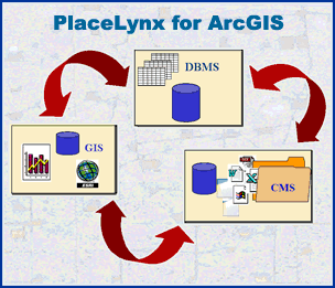
Enterprises use different technologies to manage three fundamental forms of information:
|
TABLES | Database Management System (DBMS) |
| MAPS | Geographic Information System (GIS) |
|
| FILES | Content Management System (CMS) |
Separate technologies have been optimized to manage these different forms of information ñ DBMS (database management systems) for tables, GIS (geographic information systems) for spatial data, and CMS (content management systems) for files. PlaceLynxô for ArcGIS provides integrated access to the information users need regardless of the technology that manages it.
Spatial Index for Content
PlaceLynxô for ArcGIS links documents and files in content management systems to map features in your GIS so that users can interact with a map to retrieve information.
Location as a Retrieval Key
A large percentage of the documents and files managed by utilities, energy companies, and government agencies describe something shown on a map. Consequently, a map driven user interface is often the most natural integration point for information of all sorts.
PlaceLynxô brings the full power of GIS spatial processing to bear in retrieving documents from content management and database systems.